Loading...
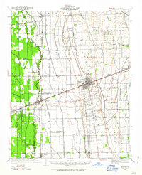
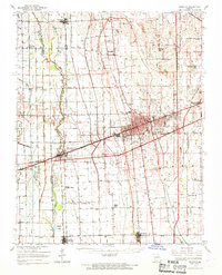
Loading map...1931 Map of Sikeston
USGS Topo · Published 1963About this map
The Missouri Bootheel landscape of the early 1930s is defined by its massive drainage infrastructure, where an intricate network of engineered channels like Ditch No 9, Ditch No 36, and the St Johns Ditch transformed the Lowlands. At the center of this transition is Sikeston, a thriving rail hub where the Missouri Pacific and St Louis - San Francisco lines intersect. These railways connect smaller agricultural outposts like Vanduser, Morehouse, and Canalou.
Find a feature on this map
87 named features on this map. Tap any name to fly to it.
Don’t see what you’re looking for? This feature index may not catch every label — zoom into the map to look around manually.
Map Details
Date Portrayed1931
Date Published1963
PublisherU.S. Geological Survey
Map TypeTopographic
Scale1:62,500
Physical Dimensions16.9 x 20.8 inches
Editions of this 1931 Sikeston Map
2 editions found

Historical Maps of Sikeston Through Time
5 maps found


Featured Locations
Source Details
SourceU.S. Geological Survey
CopyrightPublic Domain