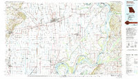
1985 Map of Sikeston
USGS Topo · Published 1994About this map
The Mississippi River creates a winding boundary between Missouri, Kentucky, and Tennessee on this mid-1980s sheet, defining a landscape of low-lying floodplains and ancient ridges. The convergence of the Ohio River near Birds Point anchors the northeast corner, while the Missouri Pacific RR and St Louis Southwestern RR intersect at Sikeston, highlighting the region's historical reliance on both rail and water transport.
Find a feature on this map
193 named features on this map. Tap any name to fly to it.
Don’t see what you’re looking for? This feature index may not catch every label — zoom into the map to look around manually.
Map Details
Editions of this 1985 Sikeston Map
2 editions found
Other maps of this area

1925 · Reelfoot Lake
USGS Topo · 1:62,500

1928 · La Center
USGS Topo · 1:62,500

1931 · Sikeston
USGS Topo · 1:62,500

1931 · Cairo
USGS Topo · 1:62,500

1932 · La Center
USGS Topo · 1:62,500

1933 · Cairo
USGS Topo · 1:62,500

1934 · Thebes
USGS Topo · 1:62,500

1934 · Morley
USGS Topo · 1:62,500

1934 · Bloomfield
USGS Topo · 1:62,500

1934 · Sikeston
USGS Topo · 1:62,500