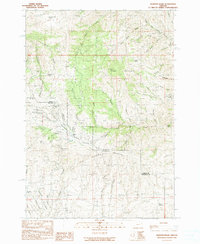
1990 Map of Mormon Basin
USGS Topo · Published 1990About this map
Pedro Mountain dominates the central terrain of this survey along the border of Baker and Malheur counties. The landscape is defined by an extensive history of resource extraction, concentrated heavily within Mormon Basin. This area is marked by numerous Prospect and Prospects labels, alongside established operations like the Sunday Hill Mine, Overshot Group Mine, and Humboldt Mine. The settlement pattern suggests the fading of once-active mining camps, with Miller (Site) and Amelia (Site) noted as former locations near the basin floor. Drainage systems including Dixie Creek and its various forks, such as South Fork Dixie Creek, have carved deep gulches like French Gulch and Emigrant Gulch, which likely served as the primary routes for early miners and settlers moving through this high-elevation mining district.
Find a feature on this map
57 named features on this map. Tap any name to fly to it.
Don’t see what you’re looking for? This feature index may not catch every label — zoom into the map to look around manually.
Map Details
Editions of this 1990 Mormon Basin Map
This is the sole edition of this map. No revisions or reprints were ever made.
Other maps of this area

1901 · Baker City
USGS Topo · 1:125,000

1915 · Pine
USGS Topo · 1:125,000

1951 · Huntington
USGS Topo · 1:62,500

1955 · Baker
USGS Topo · 1:250,000

1957 · Durkee
USGS Topo · 1:62,500

1959 · Baker
USGS Topo · 1:250,000

1964 · Bridgeport
USGS Topo · 1:62,500

1967 · French Gulch
USGS Topo · 1:24,000

1967 · Lost Basin
USGS Topo · 1:24,000

1980 · Brogan
USGS Topo · 1:100,000