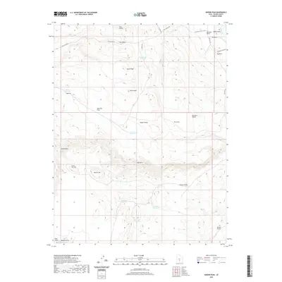
2020 Map of Moroni Peak
USGS Topo · Published 2020About this map
Moroni Peak and the curiously named Elsies Nipple dominate this high-elevation landscape on the eastern edge of the Awapa Plateau. The map reveals a land defined by water management and high-country grazing, characterized by numerous small-scale water improvements such as Long Hollow Reservoir, Cameron Reservoir, and Flat-Top Reservoir. These catchments, scattered across the terrain from Terza Flat to Bull Roost, suggest a reliance on seasonal moisture to support ranching operations in a dry environment. The topography is deeply incised by drainages like Sage Flat Draw and Big Hollow, while the eastern portion of the quadrangle descends toward Rabbit Valley. Transportation is limited to remote corridors like Long Hollow Rd and Big Rocks Rd, emphasizing the isolation of this corner of Wayne County. Historical land use is further evidenced by landmarks like Bullhead Bench and the distinct volcanic or erosional features at Big Rocks.
Find a feature on this map
35 named features on this map. Tap any name to fly to it.
Don’t see what you’re looking for? This feature index may not catch every label — zoom into the map to look around manually.
Map Details
Editions of this 2020 Moroni Peak Map
This is the sole edition of this map. No revisions or reprints were ever made.
Other maps of this area

1885 · Fish Lake
USGS Topo · 1:250,000

1896 · Fish Lake
USGS Topo · 1:250,000

1952 · Loa 1 SE
USGS Topo · 1:24,000

1952 · Loa 1 NE
USGS Topo · 1:24,000

1953 · Loa 4 NE
USGS Topo · 1:24,000

1956 · Salina
USGS Topo · 1:250,000

1960 · Salina
USGS Topo · 1:250,000

1962 · Salina
USGS Topo · 1:250,000

1967 · Lyman
USGS Topo · 1:24,000
1969 · Smooth Knoll
USGS Topo · 1:24,000