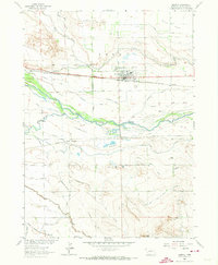
1963 Map of Morrill
USGS Topo · Published 1973About this map
Morrill stands as a focal point of Western Nebraska's agricultural and transportation corridor in the early 1960s, situated just north of the North Platte River. The landscape is defined by an intricate network of irrigation, featuring the Tri-State Canal and Main Lateral feeding into the Dutch Flats, alongside the Enterprise Canal and Ramshorn Canal closer to the riverbanks. This area highlights the transition from river-bottom farming to the rising terrain of Bald Peak in the south.
Find a feature on this map
31 named features on this map. Tap any name to fly to it.
Don’t see what you’re looking for? This feature index may not catch every label — zoom into the map to look around manually.
Map Details
Editions of this 1963 Morrill Map
2 editions found
Other maps of this area

1896 · Patrick
USGS Topo · 1:125,000

1898 · Scotts Bluff
USGS Topo · 1:125,000

1899 · Goshen Hole
USGS Topo · 1:125,000

1899 · Whistle Creek
USGS Topo · 1:125,000

1954 · Scottsbluff
USGS Topo · 1:250,000

1954 · Torrington
USGS Topo · 1:250,000

1954 · Cheyenne
USGS Topo · 1:250,000

1955 · Alliance
USGS Topo · 1:250,000

1957 · Alliance
USGS Topo · 1:250,000

1958 · Cheyenne
USGS Topo · 1:250,000