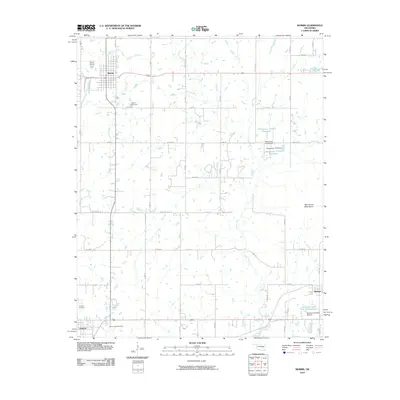
2010 Map of Morris
USGS Topo · Published 2010About this map
Morris serves as the primary hub of this Okmulgee County landscape, situated where the grid of sections meets the drainage of Cussetah Creek and Moore Creek. The area is defined by its agricultural layout, punctuated by several smaller water management features such as the Oknoname 111075 Reservoir and the Sallisaw Creek Site 34 Reservoir. Toward the south, the terrain descends toward Grayson, while the eastern portion of the sheet rises into the High Spring Mountains. For those tracing local heritage, the map identifies several key burial grounds including Morris Cemetery near the main townsite, Grayson Cemetery, and the Sacred Heart Cemetery located further south. This network of rural roads, including Ash Rd and Briar Rd, connects these scattered settlements and reflects the enduring rural character of the region as it transitioned into the early 21st century.
Find a feature on this map
43 named features on this map. Tap any name to fly to it.
Don’t see what you’re looking for? This feature index may not catch every label — zoom into the map to look around manually.
Map Details
Editions of this 2010 Morris Map
This is the sole edition of this map. No revisions or reprints were ever made.
Other maps of this area

1896 · Okmulgee
USGS Topo · 1:125,000

1900 · Canadian
USGS Topo · 1:125,000

1900 · Okmulgee
USGS Topo · 1:125,000

1946 · Fort Smith
USGS Topo · 1:250,000

1962 · Henryetta
USGS Topo · 1:24,000

1962 · Pierce
USGS Topo · 1:24,000

1962 · Hoffman
USGS Topo · 1:24,000

1965 · Fort Smith
USGS Topo · 1:250,000

1967 · Fort Smith
USGS Topo · 1:250,000
1970 · Council Hill
USGS Topo · 1:24,000