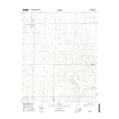
2016 Map of Morris
USGS Topo · Published 2016About this map
The town of Morris serves as the central hub of this Okmulgee County landscape, showcasing a grid of streets including W Ozark St and N 4th St that transition into a network of rural section roads like Ash Rd and Banyan Rd. The geography is defined by its transition from the northern prairie creeks such as Cussetah Creek and Moore Creek toward the elevation of the High Spring Mountains in the southeast.
Find a feature on this map
50 named features on this map. Tap any name to fly to it.
Don’t see what you’re looking for? This feature index may not catch every label — zoom into the map to look around manually.
Map Details
Editions of this 2016 Morris Map
This is the sole edition of this map. No revisions or reprints were ever made.
Other maps of this area

1896 · Okmulgee
USGS Topo · 1:125,000

1900 · Canadian
USGS Topo · 1:125,000

1900 · Okmulgee
USGS Topo · 1:125,000

1946 · Fort Smith
USGS Topo · 1:250,000

1962 · Henryetta
USGS Topo · 1:24,000

1962 · Pierce
USGS Topo · 1:24,000

1962 · Hoffman
USGS Topo · 1:24,000

1965 · Fort Smith
USGS Topo · 1:250,000

1967 · Fort Smith
USGS Topo · 1:250,000
1970 · Council Hill
USGS Topo · 1:24,000