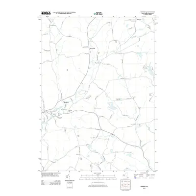
2013 Map of Morris
USGS Topo · Published 2013About this map
Butternut Cr and Wharton Cr define the drainage of this Otsego County landscape, where agriculture and early settlement patterns remain etched into the road network. The village of Morris serves as a primary hub, while smaller clusters like Welcome, New Lisbon, and West Laurens dot the intersections. For those tracing local heritage, the map identifies numerous small family and community burial sites, including the Quaker Burying Ground and Old Church Com. The presence of the Don Kichote Airport and several private airfields contrasts with the older rural character represented by Blue Bird Hill Farm and White Sky Farm. Terrain features like Gill Hill and various water bodies, such as Gilbert Lake and the unusually named Lake Misery, emphasize the rolling geography of the region. The map provides a look at the modern state of these crossroads hamlets like Naylor Corners and Stetsonville as they appeared in the early 21st century.
Find a feature on this map
115 named features on this map. Tap any name to fly to it.
Don’t see what you’re looking for? This feature index may not catch every label — zoom into the map to look around manually.
Map Details
Editions of this 2013 Morris Map
This is the sole edition of this map. No revisions or reprints were ever made.
Other maps of this area

1910 · Hartwick
USGS Topo · 1:62,500

1910 · New Berlin
USGS Topo · 1:62,500

1912 · New Berlin
USGS Topo · 1:62,500

1912 · Hartwick
USGS Topo · 1:62,500

1915 · Oneonta
USGS Topo · 1:62,500

1915 · Unadilla
USGS Topo · 1:62,500

1918 · Unadilla
USGS Topo · 1:62,500

1918 · Oneonta
USGS Topo · 1:62,500

1943 · Mt Vision
USGS Topo · 1:24,000

1943 · New Berlin North
USGS Topo · 1:24,000