1936 Map of Morrison
USGS Topo · Published 1936About this map
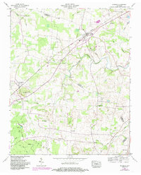
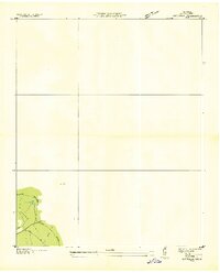
The Tennessee River Basin Divide cuts through this landscape, marking a significant hydrological boundary on the Barren Plateau south of Morrison. Surveyed in 1936 by the Tennessee Valley Authority, this advance sheet focuses on a largely unsettled terrain where natural features and emerging utility infrastructure dominate the record. Notable landmarks include Grassy Pond and the headwaters of Bark Camp Fork, which drain through the upland woods. The map captures an early stage of modern development in the region, specifically documenting the T E P C O Trans Line as it traverses the plateau, reflecting the expansion of electrical power during the mid-1930s. This specific survey was compiled using aerial photography, a relatively new technique at the time, overseen by Arthur E. Morgan.
Find a feature on this map
7 named features on this map. Tap any name to fly to it.
Don’t see what you’re looking for? This feature index may not catch every label — zoom into the map to look around manually.
Map Details
Editions of this 1936 Morrison Map
This is the sole edition of this map. No revisions or reprints were ever made.
Historical Maps of Morrison Through Time
7 maps found