
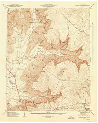
1936 Map of Cane Hollow
USGS Topo · Published 1936About this map
The Cumberland Plateau dominates this 1936 survey, showing the intricate drainage patterns of the Tennessee Basin before the landscape was heavily altered by modern development. This advance sheet, compiled from aerial photographs by the Tennessee Valley Authority, provides an early look at the region’s topography. The map centers on the high ground where State Highway No 108 follows the ridge line near the Altamont Fire Tower, a critical landmark for early forest management. Below the plateau, the headwaters of the Elk River emerge, flowing through Burrows Cove. This area is defined by numerous deep cuts like Den Hollow and Indian Hollow, while the drainage of Cane Creek and Nigger Creek illustrates the complex hydrology of Grundy County’s rim rock country during the mid-1930s.
Find a feature on this map
21 named features on this map. Tap any name to fly to it.
Don’t see what you’re looking for? This feature index may not catch every label — zoom into the map to look around manually.
Map Details
Editions of this 1936 Cane Hollow Map
This is the sole edition of this map. No revisions or reprints were ever made.
Other maps of this area

1893 · Mc Minnville
USGS Topo · 1:125,000

1895 · Mc Minnville
USGS Topo · 1:125,000

1895 · Sewanee
USGS Topo · 1:125,000

1936 · Alto
USGS Topo · 1:24,000

1936 · Burrow Cove
USGS Topo · 1:24,000

1936 · Tracy City
USGS Topo · 1:24,000

1936 · Morrison
USGS Topo · 1:24,000

1936 · Hillsboro
USGS Topo · 1:24,000

1943 · Mc Minnville
USGS Topo · 1:100,000
1947 · Burrow Cove
USGS Topo · 1:24,000