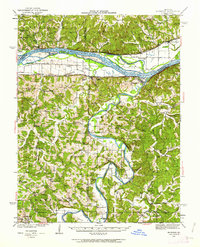
1942 Map of Morrison
USGS Topo · Published 1962About this map
The Missouri River and Gasconade River converge in this mid-century portrait of Central Missouri, where transportation remained deeply tied to the water. River islands such as Heckman Island and Portland Island dominate the wide Missouri valley, while the Missouri Pacific railroad tracks follow the northern shoreline through Bluffton and Rhineland. The landscape is a network of small agricultural settlements and family-named landmarks, reflecting a era when rural life was anchored by local institutions like the Starke Sch and St Johns Ch.
Find a feature on this map
79 named features on this map. Tap any name to fly to it.
Don’t see what you’re looking for? This feature index may not catch every label — zoom into the map to look around manually.
Map Details
Editions of this 1942 Morrison Map
2 editions found

Other maps of this area

1890 · Hermann
USGS Topo · 1:125,000

1890 · Fulton
USGS Topo · 1:125,000

1903 · Sullivan
USGS Topo · 1:125,000

1928 · Fulton
USGS Topo · 1:62,500

1931 · Fulton
USGS Topo · 1:62,500

1934 · Linn
USGS Topo · 1:48,000

1934 · Bland
USGS Topo · 1:62,500

1935 · Gerald
USGS Topo · 1:48,000

1935 · Morrison
USGS Topo · 1:48,000

1936 · Hermann
USGS Topo · 1:48,000