
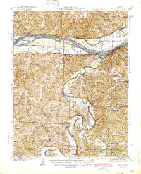
1945 Map of Morrison
USGS Topo · Published 1945About this map
The confluence of the Missouri River and the Gasconade River anchors this mid-century survey, revealing a landscape defined by seasonal waterways and island-braided channels. Near the town of Gasconade, the Missouri Pacific railroad follows the southern bank of the Missouri, connecting riverfront settlements like Morrison and Bluffton. Further inland, the terrain is dotted with an intricate network of rural institutions, including Oklahoma Ch, St Johns Creek Ch, and numerous schoolhouses such as Best Bottom Sch and Werdemann Sch. The reliance on river crossings is evidenced by the presence of the Brown Shanty Ferry and Feigler Ferry on the Gasconade, alongside the Krueger Ford further upstream. These features, along with family-named burial grounds like Woods Cem and Baecker Cem, provide a detailed record of the German-settled river valleys in Gasconade Co and neighboring counties.
Find a feature on this map
90 named features on this map. Tap any name to fly to it.
Don’t see what you’re looking for? This feature index may not catch every label — zoom into the map to look around manually.
Map Details
Editions of this 1945 Morrison Map
2 editions found
Other maps of this area

1890 · Hermann
USGS Topo · 1:125,000

1890 · Fulton
USGS Topo · 1:125,000

1903 · Sullivan
USGS Topo · 1:125,000

1928 · Fulton
USGS Topo · 1:62,500

1931 · Fulton
USGS Topo · 1:62,500

1934 · Linn
USGS Topo · 1:48,000

1934 · Bland
USGS Topo · 1:62,500

1935 · Gerald
USGS Topo · 1:48,000

1935 · Morrison
USGS Topo · 1:48,000

1936 · Hermann
USGS Topo · 1:48,000