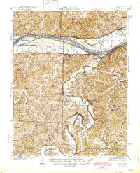
1945 Map of Morrison
USGS Topo · Published 1945About this map
The Missouri River and Gasconade River define the life and geography of this mid-Missouri region, where several large river islands like Portland Island and Heckman Island are charted mid-stream. The landscape is a network of small upland farming communities and valley settlements connected by the Missouri Pacific railroad, which runs along the southern bank of the Missouri through Morrison and Gasconade.
Find a feature on this map
84 named features on this map. Tap any name to fly to it.
Don’t see what you’re looking for? This feature index may not catch every label — zoom into the map to look around manually.
Map Details
Editions of this 1945 Morrison Map
2 editions found

Other maps of this area

1890 · Hermann
USGS Topo · 1:125,000

1890 · Fulton
USGS Topo · 1:125,000

1903 · Sullivan
USGS Topo · 1:125,000

1928 · Fulton
USGS Topo · 1:62,500

1931 · Fulton
USGS Topo · 1:62,500

1934 · Linn
USGS Topo · 1:48,000

1934 · Bland
USGS Topo · 1:62,500

1935 · Gerald
USGS Topo · 1:48,000

1935 · Morrison
USGS Topo · 1:48,000

1936 · Hermann
USGS Topo · 1:48,000