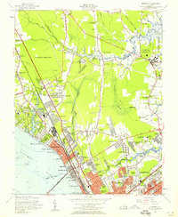
1955 Map of Morrison
USGS Topo · Published 1958About this map
The Big Bethel Battlefield and the expanding residential corridors of the mid-1950s define this landscape during a period of rapid suburbanization along the Virginia Peninsula. The City of Warwick boundary line cuts through the center of the sheet, where neighborhoods like Beaconsdale and Hilton Village align with the Chesapeake and Ohio Railway and Warwick Blvd. To the north, the U.S. Military Reservation and the Big Bethel Reservoir preserve open space, while the Mariners Museum and Lake Maury serve as significant cultural landmarks near the banks of the James River. Industrial and logistical growth is evident at Patrick Henry Airport and the numerous schools, including Mellen Sch and Parkview Sch, that supported the post-war population boom. Local spiritual life is well-documented through numerous small congregations such as Blooming Zion Ch, Ebenezer Ch, and Sinclair Chapel.
Find a feature on this map
114 named features on this map. Tap any name to fly to it.
Don’t see what you’re looking for? This feature index may not catch every label — zoom into the map to look around manually.
Map Details
Editions of this 1955 Morrison Map
This is the sole edition of this map. No revisions or reprints were ever made.
Other maps of this area

1907 · Norfolk
USGS Topo · 1:125,000

1907 · Yorktown
USGS Topo · 1:62,500

1907 · Hampton
USGS Topo · 1:62,500

1919 · Smithfield
USGS Topo · 1:62,500

1921 · Newport News
USGS Topo · 1:62,500

1943 · Yorktown
USGS Topo · 1:62,500

1943 · Richmond
USGS Topo · 1:250,000

1944 · Hampton
USGS Topo · 1:24,000

1944 · Yorktown
USGS Topo · 1:24,000

1944 · Messick
USGS Topo · 1:24,000