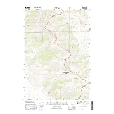
2017 Map of Morrison Lake
USGS Topo · Published 2017About this map
The Continental Divide serves as the high-altitude spine of this landscape, marking the boundary where the Beaverhead National Forest in Montana meets the Salmon National Forest in Idaho. At this intersection of Lemhi and Beaverhead Counties, the terrain is defined by steep drainages and prominent peaks, including the high-reaching Baldy Mtn. High-elevation water features like Morrison Lake and Lake Gulch sit north of the ridge, while a network of creeks including Tenmile Cr, Clear Cr, and Poison Cr carve deep paths through the timbered slopes. The map also delineates ಹಲವಾರು numbered parcel blocks and the rugged topography of Horsethief Canyon and Long Canyon. This 2017 survey provides a precise modern look at the remote wilderness areas and forest service boundaries along the Idaho-Montana state line.
Find a feature on this map
39 named features on this map. Tap any name to fly to it.
Don’t see what you’re looking for? This feature index may not catch every label — zoom into the map to look around manually.
Map Details
Editions of this 2017 Morrison Lake Map
This is the sole edition of this map. No revisions or reprints were ever made.
Other maps of this area

1955 · Dubois
USGS Topo · 1:250,000

1956 · Morrison Lake
USGS Topo · 1:62,500

1956 · Nicholia
USGS Topo · 1:62,500

1957 · Scott Peak
USGS Topo · 1:62,500

1958 · Dubois
USGS Topo · 1:250,000

1965 · Graphite Mountain
USGS Topo · 1:24,000

1965 · Island Butte
USGS Topo · 1:24,000

1980 · Leadore
USGS Topo · 1:100,000

1983 · Dubois
USGS Topo · 1:100,000
1987 · Eighteenmile Peak
USGS Topo · 1:24,000