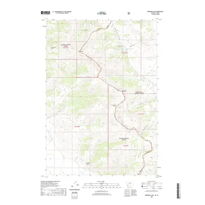
2020 Map of Morrison Lake
USGS Topo · Published 2020About this map
The Continental Divide National Scenic Trail winds through the high elevations of the Beaverhead Mountains, tracing the border between the Salmon National Forest in Idaho and the Beaverhead National Forest in Montana. This high-country landscape is defined by its drainages, where Morrison Lake sits at the head of Lake Gulch. To the south, the topography is carved by Horsethief Canyon and Poison Cr, while the western slopes fall away into Powderhorn Gulch. The Continental Divide itself serves as the primary surveyor's benchmark, splitting the waters that flow toward the Pacific and the Atlantic. This area remains largely defined by its natural hydrology and forest boundaries, with significant peaks like Baldy Mtn overseeing a network of creeks including Tenmile Cr and Simpson Cr.
Find a feature on this map
30 named features on this map. Tap any name to fly to it.
Don’t see what you’re looking for? This feature index may not catch every label — zoom into the map to look around manually.
Map Details
Editions of this 2020 Morrison Lake Map
This is the sole edition of this map. No revisions or reprints were ever made.
Other maps of this area

1955 · Dubois
USGS Topo · 1:250,000

1956 · Morrison Lake
USGS Topo · 1:62,500

1956 · Nicholia
USGS Topo · 1:62,500

1957 · Scott Peak
USGS Topo · 1:62,500

1958 · Dubois
USGS Topo · 1:250,000

1965 · Graphite Mountain
USGS Topo · 1:24,000

1965 · Island Butte
USGS Topo · 1:24,000

1980 · Leadore
USGS Topo · 1:100,000

1983 · Dubois
USGS Topo · 1:100,000
1987 · Eighteenmile Peak
USGS Topo · 1:24,000