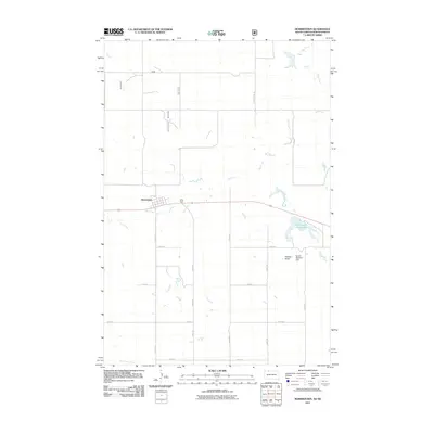
2011 Map of Morristown
USGS Topo · Published 2011About this map
Morristown stands as the primary settlement on this High Plains landscape, situated along a grid of section-line roads and the winding path of Hay Creek. The town's small residential block structure is clearly defined north of the creek, which meanders eastward toward the Morristown East Lake. This area of Corson County reflects a classic rural South Dakota layout where the economy and community are tethered to water management and land division. The presence of the Robert Bubbers Dam south of the lake highlights the importance of water infrastructure in this dry environment. Further south, the terrain rises toward Peaked Butte, a distinct natural landmark that breaks the steady rhythm of the 100-series streets and numbered avenues like 220th Ave and 224th Ave. This survey provides a precise record of local geography, from the drainage of Dirt Lodge Creek to the established transportation network of the early 21st century.
Find a feature on this map
17 named features on this map. Tap any name to fly to it.
Don’t see what you’re looking for? This feature index may not catch every label — zoom into the map to look around manually.
Map Details
Editions of this 2011 Morristown Map
This is the sole edition of this map. No revisions or reprints were ever made.
Other maps of this area

1953 · McIntosh
USGS Topo · 1:250,000

1954 · Bismarck
USGS Topo · 1:250,000

1958 · Bismarck
USGS Topo · 1:250,000

1958 · McIntosh
USGS Topo · 1:250,000

1972 · Morristown
USGS Topo · 1:24,000

1972 · Pretty Rock Butte SE
USGS Topo · 1:24,000

1972 · Morristown SE
USGS Topo · 1:24,000

1972 · Skull Butte
USGS Topo · 1:24,000

1972 · Thunder Hawk SE
USGS Topo · 1:24,000
1972 · Keldron
USGS Topo · 1:24,000
Featured Places
- Morristown, Rock Creek District
- Porcupine District, ND
- Rock Creek District, SD
- Sioux County, ND
- Corson County, SD