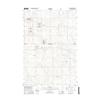
2015 Map of Morristown
USGS Topo · Published 2015About this map
Morristown sits at the intersection of prairie and plateau along the northern edge of Corson County, South Dakota. This landscape is defined by the transition from the rolling plains of the Cedar River National Grassland Beaverhead Nat For to the prominent rising form of Peaked Butte in the southeast. The settlement's layout is clearly visible, with a grid centered on Main Ave and 2nd Ave W, just south of the state boundary between North Dakota and South Dakota. Regional drainage is managed by small watercourses like Hay Cr and Dirt Lodge Cr, while local hydrology includes Morristown Lake and Morristown E Lake, which serve as significant landmarks in an otherwise arid expanse. The map illustrates the sparse, grid-based road network characteristic of the Great Plains, where section lines and county roads provide the primary structure for travel and land management.
Find a feature on this map
39 named features on this map. Tap any name to fly to it.
Don’t see what you’re looking for? This feature index may not catch every label — zoom into the map to look around manually.
Map Details
Editions of this 2015 Morristown Map
This is the sole edition of this map. No revisions or reprints were ever made.
Other maps of this area

1953 · McIntosh
USGS Topo · 1:250,000

1954 · Bismarck
USGS Topo · 1:250,000

1958 · Bismarck
USGS Topo · 1:250,000

1958 · McIntosh
USGS Topo · 1:250,000

1972 · Morristown
USGS Topo · 1:24,000

1972 · Pretty Rock Butte SE
USGS Topo · 1:24,000

1972 · Morristown SE
USGS Topo · 1:24,000

1972 · Skull Butte
USGS Topo · 1:24,000

1972 · Thunder Hawk SE
USGS Topo · 1:24,000
1972 · Keldron
USGS Topo · 1:24,000
Featured Places
- Morristown, Rock Creek District
- Porcupine District, ND
- Rock Creek District, SD
- Sioux County, ND
- Corson County, SD