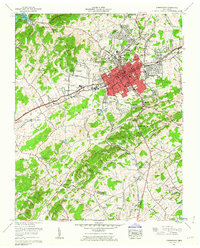
1961 Map of Morristown
USGS Topo · Published 1963About this map
Morristown serves as a bustling hub in this early 1960s survey, showing a detailed urban grid that includes Morristown College, the Post Office, and a dedicated Sewage disposal plant. The city's growth is framed by the Southern Railway and the Andrew Johnson Highway, which connect the commercial center to outlying residential areas like Hillcrest and Rolling Hills. To the west, the Morristown Municipal Airport (Merrell Field) and industrial features such as the Bell Quarry indicate a diversifying mid-century economy.
Find a feature on this map
99 named features on this map. Tap any name to fly to it.
Don’t see what you’re looking for? This feature index may not catch every label — zoom into the map to look around manually.
Map Details
Editions of this 1961 Morristown Map
2 editions found
Other maps of this area

1883 · Morristown
USGS Topo · 1:125,000

1893 · Morristown
USGS Topo · 1:125,000

1895 · Morristown
USGS Topo · 1:125,000

1935 · White Pine
USGS Topo · 1:24,000

1935 · Rogersville
USGS Topo · 1:48,000

1935 · Tate Springs
USGS Topo · 1:48,000

1935 · Springvale
USGS Topo · 1:24,000

1935 · Avondale
USGS Topo · 1:24,000

1935 · Morristown
USGS Topo · 1:24,000

1935 · Russellville
USGS Topo · 1:24,000