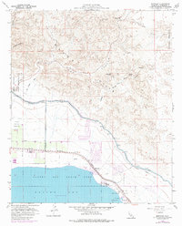
1958 Map of Mortmar
USGS Topo · Published 1977About this map
The Salton Sea shoreline dominates this 1958 survey, showing the relationship between the rising inland sea and the critical infrastructure of the Coachella Valley. The Southern Pacific railroad and the Coachella Canal run parallel to the coast, serving as lifelines through the arid landscape near Mortmar. This map captures the mid-century development of leisure and utility in the desert, from the Salton Sea State Park and Desert Beach to the industrial presence of a Gravel Pit.
Find a feature on this map
29 named features on this map. Tap any name to fly to it.
Don’t see what you’re looking for? This feature index may not catch every label — zoom into the map to look around manually.
Map Details
Editions of this 1958 Mortmar Map
3 editions found
Other maps of this area

1904 · Indio
USGS Topo · 1:125,000

1931 · Vallecito
USGS Topo · 1:125,000

1940 · Cottonwood Spring
USGS Topo · 1:62,500

1940 · Durmid
USGS Topo · 1:62,500

1941 · Coachella
USGS Topo · 1:62,500

1942 · Agua Dulce
USGS Topo · 1:62,500

1943 · Vallecito
USGS Topo · 1:125,000

1943 · Coachella
USGS Topo · 1:62,500

1944 · Agua Dulce
USGS Topo · 1:62,500

1944 · Cottonwood Spring
USGS Topo · 1:62,500