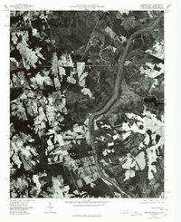
1976 Map of Morven East
USGS Topo · Published 1978About this map
The Pee Dee River dominates the eastern landscape of this Anson County orthophotograph, winding through a patchwork of cleared agricultural land and dense woodland. Prepared from 1976 aerial photography, this document provides a visual record of the rural communities along the North Carolina and South Carolina border. To the west, the settlements of Morven and Mc Farlan serve as central points for the surrounding farmsteads, while Brocks marks a smaller crossing further south. The contrast between the industrial or agricultural clearings and the natural riparian corridor of the river is starkly visible, including features like Everetts Lake set back from the main channel. This perspective captures the land-use patterns of the mid-1970s, revealing how transportation routes and small towns remained tied to the ancient path of the river and the fertile tracts of the coastal plain.
Find a feature on this map
5 named features on this map. Tap any name to fly to it.
Don’t see what you’re looking for? This feature index may not catch every label — zoom into the map to look around manually.
Map Details
Editions of this 1976 Morven East Map
This is the sole edition of this map. No revisions or reprints were ever made.
Other maps of this area

1941 · Spartanburg
USGS Topo · 1:250,000

1942 · Rockingham
USGS Topo · 1:125,000

1953 · Florence
USGS Topo · 1:250,000

1953 · Spartanburg
USGS Topo · 1:250,000

1954 · Florence
USGS Topo · 1:250,000
1956 · Rockingham
USGS Topo · 1:24,000
1956 · Lilesville
USGS Topo · 1:24,000

1956 · Wadesboro
USGS Topo · 1:24,000

1960 · Spartanburg
USGS Topo · 1:250,000

1963 · Spartanburg
USGS Topo · 1:250,000