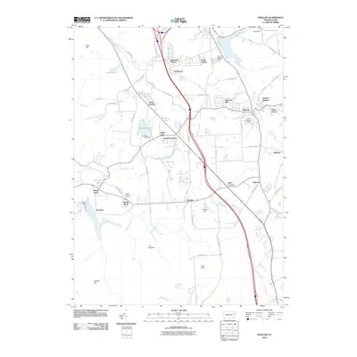
2010 Map of Moscow
USGS Topo · Published 2010About this map
Moscow serves as the focal point for this survey of the Pocono plateau's western edge in the early 21st century. The landscape is a mix of long-established rural crossroads and newer residential developments like Harmony Hills and Dawn Acres. Water management is a defining characteristic of the terrain, with infrastructure such as the Curtis Dam and Watres Dam impounding the many creeks that drain the uplands. Significant cemeteries like Saint Catherines Cemetery and Fairview Memorial Estate provide valuable landmarks for genealogists. The road network connects older hamlets including Daleville, Yostville, and Spring Brook, while prominent physical features like The Hogback and Blair Hill overlook the winding courses of Roaring Brook and Stafford Meadow Brook. This map documents a period of suburban infill amidst a historically agrarian and hydraulic landscape.
Find a feature on this map
72 named features on this map. Tap any name to fly to it.
Don’t see what you’re looking for? This feature index may not catch every label — zoom into the map to look around manually.
Map Details
Editions of this 2010 Moscow Map
This is the sole edition of this map. No revisions or reprints were ever made.
Other maps of this area

1889 · Scranton
USGS Topo · 1:62,500

1891 · Scranton
USGS Topo · 1:62,500

1893 · Scranton
USGS Topo · 1:62,500

1919 · Pocono
USGS Topo · 1:62,500

1921 · Pocono
USGS Topo · 1:62,500

1922 · Stoddartsville
USGS Topo · 1:62,500

1923 · Pocono
USGS Topo · 1:62,500

1924 · Stoddartsville
USGS Topo · 1:62,500

1928 · Ariel
USGS Topo · 1:62,500

1932 · Ariel
USGS Topo · 1:62,500