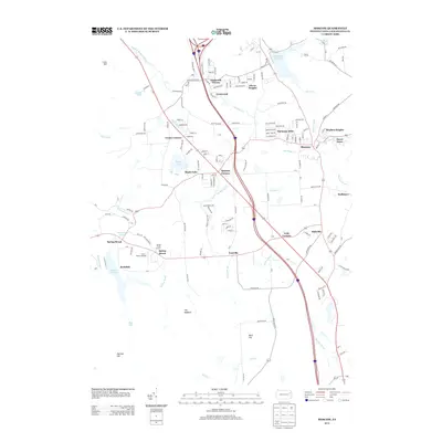
2013 Map of Moscow
USGS Topo · Published 2013About this map
Moscow serves as a central hub in this part of Lackawanna County, situated along the Roaring Brook and surrounded by a series of residential developments including Stephen Heights, Harmony Hills, and Dawn Acres. The landscape is defined by its water resources, notably the expansive Watres Reservoir to the southwest and Elmhurst Reservoir to the north, which collect the flow from numerous streams like Stafford Meadow Brook and Six Springs Cr. A mix of small settlements and named intersections such as Fells Corners, Quinlan Corners, and Yostville suggests a long-established pattern of rural crossroad communities. In the west, the Lazy J. Ranch Airport sits near Spring Brook Corners, while prominent terrain features like The Hogback and Blair Hill overlook the valleys of Ash Cr and Mash Cr. The network of local roads and interstate corridors illustrates the area's continued role as a residential and transit corridor within the greater Scranton region.
Find a feature on this map
160 named features on this map. Tap any name to fly to it.
Don’t see what you’re looking for? This feature index may not catch every label — zoom into the map to look around manually.
Map Details
Editions of this 2013 Moscow Map
This is the sole edition of this map. No revisions or reprints were ever made.
Other maps of this area

1889 · Scranton
USGS Topo · 1:62,500

1891 · Scranton
USGS Topo · 1:62,500

1893 · Scranton
USGS Topo · 1:62,500

1919 · Pocono
USGS Topo · 1:62,500

1921 · Pocono
USGS Topo · 1:62,500

1922 · Stoddartsville
USGS Topo · 1:62,500

1923 · Pocono
USGS Topo · 1:62,500

1924 · Stoddartsville
USGS Topo · 1:62,500

1928 · Ariel
USGS Topo · 1:62,500

1932 · Ariel
USGS Topo · 1:62,500