
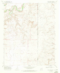
1966 Map of Moser Ranch
USGS Topo · Published 1968About this map
Moser Ranch and Rafts Ranch anchor this West Texas landscape, illustrating the enduring cattle ranching tradition of the Panhandle. The topography is defined by the winding course of Mujares Creek, which cuts through the high plains terrain and creates complex drainage patterns across the county line. The Chicago Rock Island and Pacific railroad traverses the northern portion of the sheet, serving as a primary transit corridor for the region during the mid-1960s. This survey, conducted just before the close of the decade, highlights the subtle infrastructure of the era, from a solitary Radio Tower to the industrial presence of a Pipeline and scattered Well sites. These features collectively reflect the intersection of traditional land use and the modernization of the rural Texas interior.
Find a feature on this map
9 named features on this map. Tap any name to fly to it.
Don’t see what you’re looking for? This feature index may not catch every label — zoom into the map to look around manually.
Map Details
Editions of this 1966 Moser Ranch Map
This is the sole edition of this map. No revisions or reprints were ever made.
Other maps of this area

1954 · Tucumcari
USGS Topo · 1:250,000

1958 · Tucumcari
USGS Topo · 1:250,000

1966 · Signal Spring
USGS Topo · 1:24,000

1966 · Boise
USGS Topo · 1:24,000

1966 · Signal Spring SE
USGS Topo · 1:24,000

1966 · Sand Point
USGS Topo · 1:24,000

1966 · Norton Lake
USGS Topo · 1:24,000

1968 · Rock Camp
USGS Topo · 1:24,000

1968 · Glenrio
USGS Topo · 1:24,000
1968 · Martin Draw
USGS Topo · 1:24,000