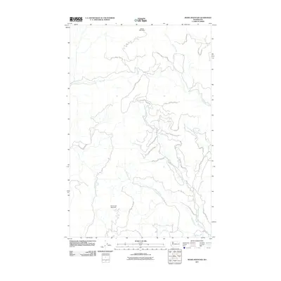
2011 Map of Moses Mountain
USGS Topo · Published 2011About this map
Colville Indian Reservation lands dominate this high-altitude landscape in Okanogan County, centered on the prominent peaks of Moses Mountain and Armstrong Mountain. The terrain is defined by a complex network of drainage basins, where waterways like Trail Creek and Omak Creek carve through the upland interior. A system of Bureau of Indian Affairs routes, including BIA 56 Rd and BIA 1022 Rd, provides the primary access through this territory, tracing the contours of the land between creek beds. The map shows a clear pattern of land management and traditional geography, with many drainages such as Whitelaw Creek and Mill Creek serving as the focal points for the sparse infrastructure in this part of Washington.
Find a feature on this map
15 named features on this map. Tap any name to fly to it.
Don’t see what you’re looking for? This feature index may not catch every label — zoom into the map to look around manually.
Map Details
Editions of this 2011 Moses Mountain Map
This is the sole edition of this map. No revisions or reprints were ever made.
Other maps of this area

1950 · Nespelem
USGS Topo · 1:62,500

1950 · Alameda Flat
USGS Topo · 1:62,500

1952 · Alameda Flat
USGS Topo · 1:62,500

1952 · Disautel
USGS Topo · 1:62,500

1953 · Bald Knob
USGS Topo · 1:62,500

1954 · Okanogan
USGS Topo · 1:250,000

1958 · Okanogan
USGS Topo · 1:250,000
1983 · Omak
USGS Topo · 1:100,000

1984 · Nespelem
USGS Topo · 1:100,000
1989 · Disautel
USGS Topo · 1:24,000