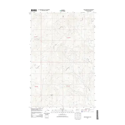
2014 Map of Moses Mountain
USGS Topo · Published 2014About this map
Colville Indian Reservation lands dominate this high-elevation region of Okanogan County, centered on the prominent summit of Moses Mtn. The landscape is defined by a dense network of high-country drainages including Omak Cr, Mill Cr, and Whitelaw Cr, which carve through the terrain south of Armstrong Mtn. This survey captures the specialized road network of the Bureau of Indian Affairs, featuring routes like BIA 1055 Rd and BIA 1132 Rd that provide access to these protected lands. The drainage patterns of Trail Cr and N Star Cr suggest a complex topography of ridges and valleys typical of the interior Northwest, where water sources dictated the placement of early travel corridors and land management boundaries.
Find a feature on this map
18 named features on this map. Tap any name to fly to it.
Don’t see what you’re looking for? This feature index may not catch every label — zoom into the map to look around manually.
Map Details
Editions of this 2014 Moses Mountain Map
This is the sole edition of this map. No revisions or reprints were ever made.
Other maps of this area

1950 · Nespelem
USGS Topo · 1:62,500

1950 · Alameda Flat
USGS Topo · 1:62,500

1952 · Alameda Flat
USGS Topo · 1:62,500

1952 · Disautel
USGS Topo · 1:62,500

1953 · Bald Knob
USGS Topo · 1:62,500

1954 · Okanogan
USGS Topo · 1:250,000

1958 · Okanogan
USGS Topo · 1:250,000
1983 · Omak
USGS Topo · 1:100,000

1984 · Nespelem
USGS Topo · 1:100,000
1989 · Disautel
USGS Topo · 1:24,000