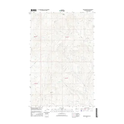
2017 Map of Moses Mountain
USGS Topo · Published 2017About this map
Moses Mountain and Armstrong Mtn dominate the high-elevation terrain of this Okanogan County landscape, where the Bureau of Indian Affairs (BIA) road network provides the primary access through the drainage basins. A complex system of seasonal and perennial streams, including Whitelaw Cr and Omak Cr, carves through the topography, reflecting a drainage pattern that supports the region's natural ecosystem. The presence of numerous BIA routes, such as Bia RD 56 and Bia RD 109, underscores the significance of this area within the Colville Indian Reservation. These corridors connect the various mountain ridges and creek valleys, such as Mill Cr and Parmenter Cr, providing a detailed look at the resource management and infrastructure of the 21st-century tribal lands.
Find a feature on this map
20 named features on this map. Tap any name to fly to it.
Don’t see what you’re looking for? This feature index may not catch every label — zoom into the map to look around manually.
Map Details
Editions of this 2017 Moses Mountain Map
This is the sole edition of this map. No revisions or reprints were ever made.
Other maps of this area

1950 · Nespelem
USGS Topo · 1:62,500

1950 · Alameda Flat
USGS Topo · 1:62,500

1952 · Alameda Flat
USGS Topo · 1:62,500

1952 · Disautel
USGS Topo · 1:62,500

1953 · Bald Knob
USGS Topo · 1:62,500

1954 · Okanogan
USGS Topo · 1:250,000

1958 · Okanogan
USGS Topo · 1:250,000
1983 · Omak
USGS Topo · 1:100,000

1984 · Nespelem
USGS Topo · 1:100,000
1989 · Disautel
USGS Topo · 1:24,000