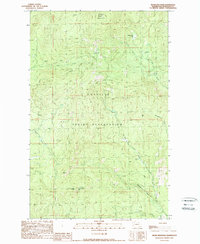
1989 Map of Moses Mountain
USGS Topo · Published 1989About this map
Colville Indian Reservation land defines this portion of Okanogan County, characterized by high-elevation peaks and a dense network of mountain streams. High points like Moses Mountain and Armstrong Mtn dominate the topography, with a specialized Lookout Tower Moses Mtn positioned at the summit of the former to monitor the surrounding timberlands. The hydrology of the area is particularly complex, with numerous drainages such as Whitelaw Creek, Mill Creek, and Omak Creek carving through the terrain. The presence of North Star Lake in the northeastern section provides a rare standing water feature amidst the steep ridges. This 1989 provisional edition serves as a record of the wilderness and resource management infrastructure within the reservation before modern digital mapping, showing primitive roads and trails that intersect the various creek basins.
Find a feature on this map
16 named features on this map. Tap any name to fly to it.
Don’t see what you’re looking for? This feature index may not catch every label — zoom into the map to look around manually.
Map Details
Editions of this 1989 Moses Mountain Map
This is the sole edition of this map. No revisions or reprints were ever made.
Other maps of this area

1950 · Nespelem
USGS Topo · 1:62,500

1950 · Alameda Flat
USGS Topo · 1:62,500

1952 · Alameda Flat
USGS Topo · 1:62,500

1952 · Disautel
USGS Topo · 1:62,500

1953 · Bald Knob
USGS Topo · 1:62,500

1954 · Okanogan
USGS Topo · 1:250,000

1958 · Okanogan
USGS Topo · 1:250,000
1983 · Omak
USGS Topo · 1:100,000

1984 · Nespelem
USGS Topo · 1:100,000
1989 · Disautel
USGS Topo · 1:24,000