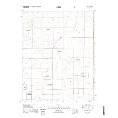
2020 Map of Moses
USGS Topo · Published 2020About this map
Old Moses and the nearby settlement of Moses sit at the intersection of Union County high plains and the Oklahoma state line in this recent topographic study. The landscape is defined by the winding course of Corrumpa Creek and its seasonal drainages, including Rinker Draw and Plunket Draw. Large sections of the Kiowa National Grassland are interspersed among private ranch lands, preserving a snapshot of the shortgrass prairie environment. Genealogists will find several small burial sites documented across the quadrangle, notably Puertocito Cem, Moses Cem, and Rinker Cem. Local landmarks such as Elephant Rock and Correo Spring offer specific points of interest along the rural road network, which includes Campbell Rd and Atencio Rd. This survey details the borderlands where New Mexico meets the Oklahoma Panhandle, showing the sparse but persistent ranching infrastructure of the region.
Find a feature on this map
27 named features on this map. Tap any name to fly to it.
Don’t see what you’re looking for? This feature index may not catch every label — zoom into the map to look around manually.
Map Details
Editions of this 2020 Moses Map
This is the sole edition of this map. No revisions or reprints were ever made.
Other maps of this area

1954 · Dalhart
USGS Topo · 1:250,000

1958 · Dalhart
USGS Topo · 1:250,000

1962 · Dalhart
USGS Topo · 1:250,000

1969 · Felt SW
USGS Topo · 1:24,000

1969 · Wheeless
USGS Topo · 1:24,000
1969 · Kenton SW
USGS Topo · 1:24,000

1972 · Seneca
USGS Topo · 1:24,000

1972 · Atencio
USGS Topo · 1:24,000

1972 · Rardin Hill
USGS Topo · 1:24,000

1972 · Moses
USGS Topo · 1:24,000