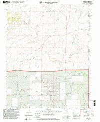
1998 Map of Moses
USGS Topo · Published 2001About this map
Santa Fe Trail (Cimarron Cutoff) traces a diagonal path across this high plains landscape, marking the enduring legacy of the historic trade route through Union County. The small settlement of Moses and the nearby site of Old Moses serve as the primary human nodes in a region defined by wide-open spaces and essential water sources like Corrumpa Creek and South Carrizo Creek. The presence of several family or community burial grounds, including Puertocito Cem, Moses Cem, and Rinker Cem, offers significant detail for those tracing regional lineage.
Find a feature on this map
30 named features on this map. Tap any name to fly to it.
Don’t see what you’re looking for? This feature index may not catch every label — zoom into the map to look around manually.
Map Details
Editions of this 1998 Moses Map
This is the sole edition of this map. No revisions or reprints were ever made.
Other maps of this area

1954 · Dalhart
USGS Topo · 1:250,000

1958 · Dalhart
USGS Topo · 1:250,000

1962 · Dalhart
USGS Topo · 1:250,000

1969 · Felt SW
USGS Topo · 1:24,000

1969 · Wheeless
USGS Topo · 1:24,000
1969 · Kenton SW
USGS Topo · 1:24,000

1972 · Seneca
USGS Topo · 1:24,000

1972 · Atencio
USGS Topo · 1:24,000

1972 · Rardin Hill
USGS Topo · 1:24,000

1972 · Moses
USGS Topo · 1:24,000