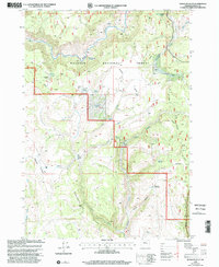
1999 Map of Mosquito Flat
USGS Topo · Published 2002About this map
Malheur National Forest dominates this high-desert landscape in Harney County, where the topography is defined by the Silvies River and a network of drainages including Poison Creek and Stancliffe Creek. The terrain transitions from the elevations of Gravel Ridge and Mahogany Ridge down toward the open expanse of Mosquito Flat. This 1990s record of the high country highlights the enduring presence of early 20th-century land claims and agricultural outposts. Evidence of ranching history is scattered across the township lines, notably at Whiting Ranch, Groff Ranch, and the Peabody Homestead. Remote working sites like the Cow Camp (Site) reflect the seasonal livestock movements typical of this region, while numerous named springs such as Rimrock Spring and Lone Pine Spring mark critical water sources in the arid Harney Basin environment.
Find a feature on this map
27 named features on this map. Tap any name to fly to it.
Don’t see what you’re looking for? This feature index may not catch every label — zoom into the map to look around manually.
Map Details
Editions of this 1999 Mosquito Flat Map
This is the sole edition of this map. No revisions or reprints were ever made.
Other maps of this area

1955 · Burns
USGS Topo · 1:250,000

1958 · Burns
USGS Topo · 1:250,000

1959 · Burns
USGS Topo · 1:250,000

1959 · West Myrtle Butte
USGS Topo · 1:62,500

1959 · Harney
USGS Topo · 1:62,500

1960 · Burns
USGS Topo · 1:62,500

1961 · Calamity Butte
USGS Topo · 1:62,500

1978 · Stinkingwater Mountains
USGS Topo · 1:100,000
1990 · Poison Creek
USGS Topo · 1:24,000
1990 · Burns NW
USGS Topo · 1:24,000