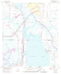
1955 Map of Moss Lake
USGS Topo · Published 1986About this map
The Calcasieu Ship Channel dominates this coastal Louisiana landscape, cutting a deep-water path through the marshes of Calcasieu Parish and Cameron Parish. At the southern edge, the settlement of Hackberry serves as a hub for the sprawling Hackberry Oil Field, where numerous well pads and access roads mark the industrial footprint on the wetlands. The confluence of the Calcasieu River, Moss Lake, and the Intracoastal Waterway illustrates a complex mid-century transport network designed for both petroleum extraction and regional maritime commerce. Smaller local landmarks such as Christian Ch and several family burial grounds, including Benoit Cem and Dutch Cove Cem, provide essential points of reference for genealogists tracing the established communities that persisted alongside the rising energy industry. The geography is further defined by tidal features like Choupique Island and the transition into the broad waters of Calcasieu Lake.
Find a feature on this map
30 named features on this map. Tap any name to fly to it.
Don’t see what you’re looking for? This feature index may not catch every label — zoom into the map to look around manually.
Map Details
Editions of this 1955 Moss Lake Map
3 editions found
Other maps of this area

1932 · Moss Lake
USGS Topo · 1:31,680

1932 · Lake Charles NW
USGS Topo · 1:31,680

1932 · Lake Charles SW
USGS Topo · 1:31,680

1934 · Sweet Lake
USGS Topo · 1:24,000

1934 · Browns Lake
USGS Topo · 1:24,000

1935 · Sweet Lake
USGS Topo · 1:31,680

1935 · Hackberry
USGS Topo · 1:31,680

1935 · Browns Lake
USGS Topo · 1:31,680

1942 · Lake Charles
USGS Topo · 1:62,500

1946 · Moss Lake
USGS Topo · 1:31,680