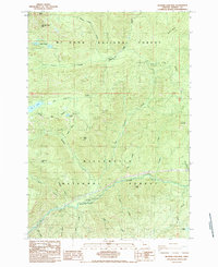
1985 Map of Mother Lode Mtn
USGS Topo · Published 1985About this map
Mt Hood National Forest and Willamette National Forest converge in this high-altitude landscape dominated by the Breitenbush River corridor. The terrain is defined by prominent peaks like Mother Lode Mtn and Pansy Mtn, with a network of drainages including Humbug Creek, Battle Creek, and Elk Lake Creek carving through the Cascades. Human activity is largely centered on recreational and utility infrastructure, represented by the Humbug Campground and the Battle Creek Shelter. The map documents a complex hydrology of alpine lakes such as Elk Lake and Twin Lakes, alongside industrial markers like a Gravel Pit and Borrow Pit, reflecting the maintenance of forest access roads. The presence of Eagle Rock and the steep Cliffs near Hoover Ridge highlights the dramatic verticality of this forest interior during the mid-1980s.
Find a feature on this map
35 named features on this map. Tap any name to fly to it.
Don’t see what you’re looking for? This feature index may not catch every label — zoom into the map to look around manually.
Map Details
Editions of this 1985 Mother Lode Mtn Map
This is the sole edition of this map. No revisions or reprints were ever made.
Other maps of this area

1927 · Mt. Jefferson
USGS Topo · 1:125,000

1929 · Mill City
USGS Topo · 1:125,000

1930 · Mt. Jefferson
USGS Topo · 1:125,000

1953 · Salem
USGS Topo · 1:250,000

1954 · Salem
USGS Topo · 1:250,000

1955 · Bend
USGS Topo · 1:250,000

1956 · Battle Ax
USGS Topo · 1:62,500

1956 · Detroit
USGS Topo · 1:62,500

1957 · Bend
USGS Topo · 1:250,000

1958 · Bend
USGS Topo · 1:250,000