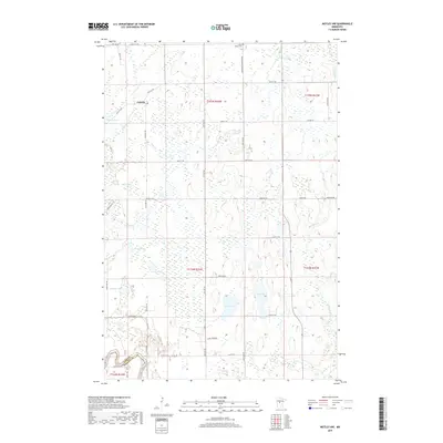
2019 Map of Motley NW
USGS Topo · Published 2019About this map
Esterdy sits at the intersection of rural routes and wetlands in this transition zone between Cass and Wadena counties. The landscape is defined by a dense network of glacial water bodies, from the centrally located Dog Lake and its neighbor Cat Lake to smaller pockets like Pulvers Lake and Farber Lake. These features, along with winding waterways like Swan Creek and Mosquito Creek, dictate the placement of the section-line roads that carve through the timber and marshland.
Find a feature on this map
42 named features on this map. Tap any name to fly to it.
Don’t see what you’re looking for? This feature index may not catch every label — zoom into the map to look around manually.
Map Details
Editions of this 2019 Motley NW Map
This is the sole edition of this map. No revisions or reprints were ever made.
Other maps of this area

1919 · Leader
USGS Topo · 1:62,500

1953 · Brainerd
USGS Topo · 1:250,000

1957 · Brainerd
USGS Topo · 1:250,000

1958 · Brainerd
USGS Topo · 1:250,000
1963 · Motley SE
USGS Topo · 1:24,000

1963 · Motley
USGS Topo · 1:24,000

1965 · Brainerd
USGS Topo · 1:250,000

1966 · Staples NE
USGS Topo · 1:24,000
1966 · Casino
USGS Topo · 1:24,000
1966 · Motley NW
USGS Topo · 1:24,000