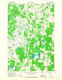
1966 Map of Motley NW
USGS Topo · Published 1967About this map
Iron Creek and its many tributaries wind through a landscape defined by glacial wetlands and small lakes in the mid-1960s. The settlement of Esterly stands near the northern reaches of this rural territory, while the Crow Wing River cuts through the southwestern corner near Thomastown. Local civic and social life is anchored by the Townhall and the Meadow Brook Sch, reflecting a sparse but established community infrastructure in the townships of Byron, Meadow Brook, Becker, and May.
Find a feature on this map
22 named features on this map. Tap any name to fly to it.
Don’t see what you’re looking for? This feature index may not catch every label — zoom into the map to look around manually.
Map Details
Editions of this 1966 Motley NW Map
This is the sole edition of this map. No revisions or reprints were ever made.
Other maps of this area

1919 · Leader
USGS Topo · 1:62,500

1953 · Brainerd
USGS Topo · 1:250,000

1957 · Brainerd
USGS Topo · 1:250,000

1958 · Brainerd
USGS Topo · 1:250,000
1963 · Motley SE
USGS Topo · 1:24,000

1963 · Motley
USGS Topo · 1:24,000

1965 · Brainerd
USGS Topo · 1:250,000

1966 · Staples NE
USGS Topo · 1:24,000
1966 · Casino
USGS Topo · 1:24,000

1966 · Staples
USGS Topo · 1:24,000