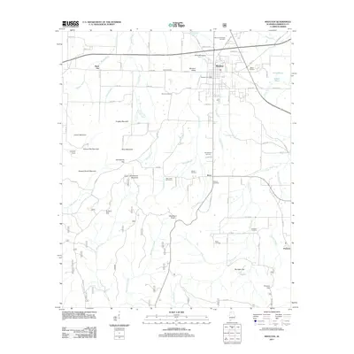
2011 Map of Moulton
USGS Topo · Published 2011About this map
Moulton sits at the heart of this Lawrence County landscape, established near the junction of Byler Rd and the central corridor of Moulton Valley. The town's civic structure is marked by the Moulton Post Office and several family burial grounds, including the Milam Cemetery and Heflin Cemetery. To the south, the terrain becomes increasingly complex as the valley floor gives way to a series of elevations and gaps. Notable landforms such as Srygley Mountain, Cheatham Knob, and Buzzard Roost Mountain define the topography, while low-lying areas are drained by a network of waterways including Sledge Creek, Almon Branch, and Elam Creek. The map documents numerous smaller communities and locales such as Wren, Muck City, and Pinhook, illustrating a settlement pattern deeply influenced by the gaps between the mountains, such as Penitentiary Gap and Mulligan Gap.
Find a feature on this map
89 named features on this map. Tap any name to fly to it.
Don’t see what you’re looking for? This feature index may not catch every label — zoom into the map to look around manually.
Map Details
Editions of this 2011 Moulton Map
This is the sole edition of this map. No revisions or reprints were ever made.
Other maps of this area

1935 · Moulton
USGS Topo · 1:24,000

1935 · Upshaw
USGS Topo · 1:24,000

1935 · Danville
USGS Topo · 1:48,000

1935 · Oakville
USGS Topo · 1:24,000

1936 · Caddo
USGS Topo · 1:24,000

1936 · Moulton
USGS Topo · 1:48,000

1936 · Masterson
USGS Topo · 1:24,000

1936 · Hatton
USGS Topo · 1:24,000

1936 · Landersville
USGS Topo · 1:24,000

1938 · Danville
USGS Topo · 1:62,500