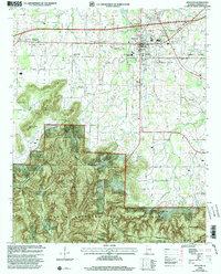
2000 Map of Moulton
USGS Topo · Published 2003About this map
Moulton serves as the focal point of this Lawrence County landscape, marking the transition from the relatively level agricultural lands of the Moulton Valley to the heavily forested uplands of the south. The historical footprint of the area is traced by Byler Road, one of Alabama's earliest state roads, which skirts the western edges of the William B Bankhead National Forest. To the south, the terrain rises sharply into the high ridges of Penitentiary Mountain and Buzzard Roost Mountain, land protected within the Black Warrior Wildlife Management Area.
Find a feature on this map
47 named features on this map. Tap any name to fly to it.
Don’t see what you’re looking for? This feature index may not catch every label — zoom into the map to look around manually.
Map Details
Editions of this 2000 Moulton Map
This is the sole edition of this map. No revisions or reprints were ever made.
Other maps of this area

1935 · Moulton
USGS Topo · 1:24,000

1935 · Upshaw
USGS Topo · 1:24,000

1935 · Danville
USGS Topo · 1:48,000

1935 · Oakville
USGS Topo · 1:24,000

1936 · Caddo
USGS Topo · 1:24,000

1936 · Moulton
USGS Topo · 1:48,000

1936 · Masterson
USGS Topo · 1:24,000

1936 · Hatton
USGS Topo · 1:24,000

1936 · Landersville
USGS Topo · 1:24,000

1938 · Danville
USGS Topo · 1:62,500