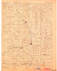
1893 Map of Mound City
USGS Topo · Published 1900About this map
The Marais Des Cygnes or Osage River defines the central axis of this late-19th-century landscape, carving a meandering path through eastern Kansas. This survey shows the region as it transitioned from an agrarian frontier to a rail-connected economy, with the Kansas City Osage and Gulf Railroad running north-to-south through La Cygne and Pleasanton. To the west, the St Louis Emporia and Western Railroad links the settlement of Mound City toward the hills of Blue Mound. The terrain is deeply etched by a network of drainage systems like Little Sugar Creek and Mine Creek, while the boundary line with Missouri appears along the eastern edge of West Point and Homer. Smaller rural outposts such as Farlinville and New Lancaster suggest the density of local commerce before the era of modern highway development.
Find a feature on this map
72 named features on this map. Tap any name to fly to it.
Don’t see what you’re looking for? This feature index may not catch every label — zoom into the map to look around manually.
Map Details
Editions of this 1893 Mound City Map
4 editions found

Other maps of this area

1884 · Fort Scott
USGS Topo · 1:125,000

1885 · Garnett
USGS Topo · 1:125,000

1885 · Lawrence
USGS Topo · 1:125,000

1886 · Nevada
USGS Topo · 1:125,000

1886 · Iola
USGS Topo · 1:125,000

1886 · Fort Scott
USGS Topo · 1:125,000

1887 · Harrisonville
USGS Topo · 1:125,000

1887 · Olathe
USGS Topo · 1:125,000

1887 · Butler
USGS Topo · 1:125,000

1887 · Mound City
USGS Topo · 1:125,000