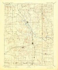
1893 Map of Mound City
USGS Topo · Published 1924About this map
Marais Des Cygnes River meanders through the heart of Linn County, defining a landscape dominated by the convergence of several major nineteenth-century rail lines. Surveyed in the 1880s, the map reveals the critical junctions at Pleasanton and Mound City, where the Kansas City Fort Scott and Gulf Railroad and the St Louis Emporia and Western Railroad facilitated the transport of cattle and agricultural goods. Smaller settlements like Farlinville and New Lancaster anchor the rural townships, while the border with Missouri is clearly delineated to the east near Hume. The terrain is etched with numerous smaller drainages, such as Big Sugar Creek and Little Sugar Creek, which influenced the placement of early homesteads and road networks in this productive section of the Kansas-Missouri borderlands.
Find a feature on this map
70 named features on this map. Tap any name to fly to it.
Don’t see what you’re looking for? This feature index may not catch every label — zoom into the map to look around manually.
Map Details
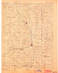
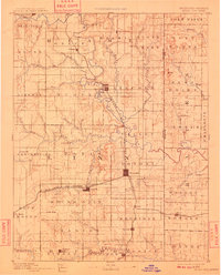
Editions of this 1893 Mound City Map
4 editions found

Other maps of this area

1884 · Fort Scott
USGS Topo · 1:125,000

1885 · Garnett
USGS Topo · 1:125,000

1885 · Lawrence
USGS Topo · 1:125,000

1886 · Nevada
USGS Topo · 1:125,000

1886 · Iola
USGS Topo · 1:125,000

1886 · Fort Scott
USGS Topo · 1:125,000

1887 · Harrisonville
USGS Topo · 1:125,000

1887 · Olathe
USGS Topo · 1:125,000

1887 · Butler
USGS Topo · 1:125,000

1887 · Mound City
USGS Topo · 1:125,000