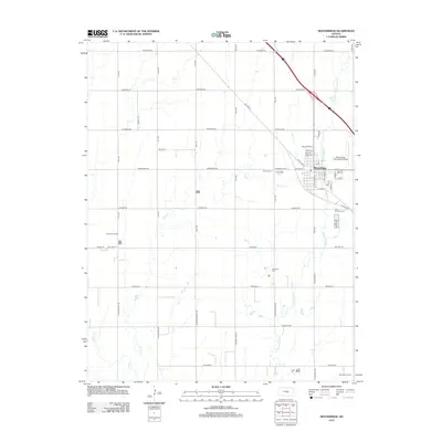
2012 Map of Moundridge
USGS Topo · Published 2012About this map
Moundridge serves as the focal point of this McPherson County survey, illustrating the grid of a classic Kansas agricultural and transit hub. The landscape is etched by the courses of Sand Cr and Black Kettle Cr, which wind through a township defined by a rigid section-line road system including Cheyenne Rd and Arapaho Rd. Local history is anchored by several distinct burial grounds, such as Mound Cem, Schlender Cem, and the First Christian Cem, reflecting the area's pioneer and denominational roots. The map also documents the region's energy and infrastructure interests, noting the Harmac Oil Field to the west and the Sperling Oil Field in the southeast corner. Transportation is well-represented by the Moundridge Municipal Airfield and the historic path of Old US Hwy 81, which angles across the prairie north of the town center.
Find a feature on this map
55 named features on this map. Tap any name to fly to it.
Don’t see what you’re looking for? This feature index may not catch every label — zoom into the map to look around manually.
Map Details
Editions of this 2012 Moundridge Map
This is the sole edition of this map. No revisions or reprints were ever made.
Other maps of this area

1889 · Newton
USGS Topo · 1:125,000

1891 · Hutchinson
USGS Topo · 1:125,000

1893 · Hutchinson
USGS Topo · 1:125,000

1894 · Newton
USGS Topo · 1:125,000

1955 · Hutchinson
USGS Topo · 1:250,000

1959 · Hutchinson
USGS Topo · 1:250,000
1959 · Zimmerdale
USGS Topo · 1:24,000
1959 · Halstead
USGS Topo · 1:24,000
1959 · Burrton
USGS Topo · 1:24,000

1965 · Mc Pherson South
USGS Topo · 1:24,000