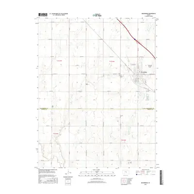
2015 Map of Moundridge
USGS Topo · Published 2015About this map
Moundridge serves as the central hub of this Central Kansas landscape, straddling the border between McPherson Co and Harvey Co. The town's grid is bounded by Moundridge Municipal Airport to the east and the historical path of Old US Hwy 81, which bypasses the town's core. Waterways like Sand Cr and Black Kettle Cr meander through the surrounding agricultural sections, which are marked by a regular network of named rural roads such as Cheyenne Rd and Arapaho Rd. Several rural burial grounds, including Schlender Cem and Mound Cem, indicate the long-standing community foundations of this region. The landscape maintains its traditional section-line organization, illustrating the persistent agrarian structure of the Kansas plains.
Find a feature on this map
32 named features on this map. Tap any name to fly to it.
Don’t see what you’re looking for? This feature index may not catch every label — zoom into the map to look around manually.
Map Details
Editions of this 2015 Moundridge Map
This is the sole edition of this map. No revisions or reprints were ever made.
Other maps of this area

1889 · Newton
USGS Topo · 1:125,000

1891 · Hutchinson
USGS Topo · 1:125,000

1893 · Hutchinson
USGS Topo · 1:125,000

1894 · Newton
USGS Topo · 1:125,000

1955 · Hutchinson
USGS Topo · 1:250,000

1959 · Hutchinson
USGS Topo · 1:250,000
1959 · Zimmerdale
USGS Topo · 1:24,000
1959 · Halstead
USGS Topo · 1:24,000
1959 · Burrton
USGS Topo · 1:24,000

1965 · Mc Pherson South
USGS Topo · 1:24,000