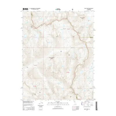
2015 Map of Mount Abbot
USGS Topo · Published 2015About this map
Sierra Nevada high country dominates this topographical study, where the borders of Fresno, Mono, and Inyo counties converge at some of California's most formidable elevations. The landscape is defined by the massive granite forms of Mount Abbot, Mt Stanford, and Mt Dade, part of a jagged relief that forms the Mono Divide. This era of the high Sierra reflects a wilderness defined by its glacial past, evidenced by the deep amphitheaters of the First Recess through the Fourth Recess and the dense clustering of alpine basins like Pioneer Basin. Strategic mountain travel is marked by high-altitude crossings such as Mono Pass and Morgan Pass, which historically linked the Owens Valley to the western slopes. A complex hydrological network feeds into Rock Cr and Mills Cr, sustaining a chain of high-altitude waters including Big McGee Lake and the Hilton Cr Lakes.
Find a feature on this map
75 named features on this map. Tap any name to fly to it.
Don’t see what you’re looking for? This feature index may not catch every label — zoom into the map to look around manually.
Map Details
Editions of this 2015 Mount Abbot Map
This is the sole edition of this map. No revisions or reprints were ever made.
Other maps of this area

1912 · Mt. Goddard
USGS Topo · 1:125,000

1914 · Mt. Morrison
USGS Topo · 1:125,000

1947 · Mariposa
USGS Topo · 1:250,000

1948 · Mariposa
USGS Topo · 1:250,000

1949 · Mt. Tom
USGS Topo · 1:62,500

1951 · Mt. Tom
USGS Topo · 1:62,500

1953 · Mt. Morrison
USGS Topo · 1:62,500

1953 · Casa Diablo Mtn
USGS Topo · 1:62,500

1953 · Mt Abbot
USGS Topo · 1:62,500
1954 · Mt. Tom
USGS Topo · 1:62,500