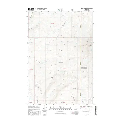
2014 Map of Mount Adams West
USGS Topo · Published 2014About this map
The massive western slopes of Mt Adams dominate this landscape within the Gifford Pinchot National Forest, where high-altitude ice and glacial melt dictate the terrain. Several prominent glaciers, including Adams Glacier, Pinnacle Glacier, and White Salmon Glacier, crown the heights of the volcano, feeding the headwaters of the Lewis River and White Salmon River. The Pacific Crest National Scenic Trail winds through the center of the sheet, crossing notable landmarks like Burnt Rock and passing near the secluded Lookingglass Lake. Below the timberline, the geography is defined by prominent rises and clearings such as Stagman Ridge, Crofton Butte, and Horseshoe Meadow. This 2014 survey records a wilderness shaped by both geologic activity and established conservation, showing the precise intersection of Skamania and Yakima counties atop the mountain's volcanic mass.
Find a feature on this map
43 named features on this map. Tap any name to fly to it.
Don’t see what you’re looking for? This feature index may not catch every label — zoom into the map to look around manually.
Map Details
Editions of this 2014 Mount Adams West Map
This is the sole edition of this map. No revisions or reprints were ever made.
Other maps of this area

1904 · Mount Adams
USGS Topo · 1:125,000

1907 · Mount Adams
USGS Topo · 1:125,000

1926 · Steamboat Mtn
USGS Topo · 1:125,000

1931 · Steamboat Mtn
USGS Topo · 1:125,000

1950 · Yakima
USGS Topo · 1:250,000

1958 · Yakima
USGS Topo · 1:250,000

1961 · Yakima
USGS Topo · 1:250,000
1970 · Sleeping Beauty
USGS Topo · 1:24,000
1970 · East Canyon Ridge
USGS Topo · 1:24,000
1970 · Trout Lake
USGS Topo · 1:24,000