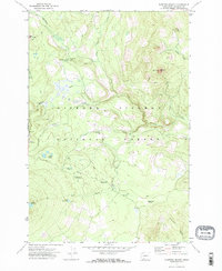
1970 Map of Sleeping Beauty
USGS Topo · Published 1973About this map
Gifford Pinchot National Forest dominates this 1970 study of high-elevation terrain in Skamania County, revealing a landscape defined by water and forest management. The area is dense with remote mountain lakes including Lake Wapiki, Lake Concomly, and the cluster at Hidden Lakes. This survey captures the infrastructure of the mid-century wilderness experience, marking established sites like Little Goose Campground and Smoky Creek Campground alongside industrial features such as scattered Gravel Pits.
Find a feature on this map
30 named features on this map. Tap any name to fly to it.
Don’t see what you’re looking for? This feature index may not catch every label — zoom into the map to look around manually.
Map Details
Editions of this 1970 Sleeping Beauty Map
This is the sole edition of this map. No revisions or reprints were ever made.
Other maps of this area

1926 · Steamboat Mtn
USGS Topo · 1:125,000

1926 · Hood River
USGS Topo · 1:125,000

1929 · Hood River
USGS Topo · 1:125,000

1931 · Steamboat Mtn
USGS Topo · 1:125,000

1950 · Yakima
USGS Topo · 1:250,000

1953 · The Dalles
USGS Topo · 1:250,000

1956 · The Dalles
USGS Topo · 1:250,000

1957 · The Dalles
USGS Topo · 1:250,000

1957 · Wind River
USGS Topo · 1:62,500

1957 · Willard
USGS Topo · 1:62,500