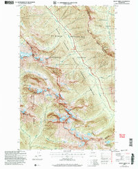
2002 Map of Mount Arriva
USGS Topo · Published 2006About this map
Mount Arriva and Fisher Peak dominate this high-altitude landscape where the boundaries of four major national forests and a national park intersect. Revised by the Forest Service at the start of the 21st century, the map details the complex terrain of Ragged Ridge and the Fisher Creek Basin. The area serves as a critical hydrologic divide, with the West Fork Methow River flowing east toward the Okanogan, while Fisher Creek and Panther Creek drain westward through the deep valleys of the North Cascades National Park. The North Cascades Scenic Highway Corridor provides the primary passage through this steep region, crossing near Mount Hardy. High mountain lakes such as Lake Ann, Wing Lake, and the Silent Lakes are scattered throughout the glacial basins, while traditional high passes like Easy Pass and Heather Pass mark the historic foot routes used to traverse the crest between Skagit and Okanogan counties.
Find a feature on this map
35 named features on this map. Tap any name to fly to it.
Don’t see what you’re looking for? This feature index may not catch every label — zoom into the map to look around manually.
Map Details
Editions of this 2002 Mount Arriva Map
This is the sole edition of this map. No revisions or reprints were ever made.
Other maps of this area

1902 · Stehekin
USGS Topo · 1:125,000

1904 · Stehekin
USGS Topo · 1:125,000

1920 · Slate Pass
USGS Topo · 1:125,000

1955 · Concrete
USGS Topo · 1:250,000

1958 · Concrete
USGS Topo · 1:250,000

1962 · Concrete
USGS Topo · 1:250,000

1963 · Washington Pass
USGS Topo · 1:24,000

1963 · Mc Gregor Mtn
USGS Topo · 1:24,000

1963 · Azurite Peak
USGS Topo · 1:24,000

1963 · Slate Peak
USGS Topo · 1:24,000