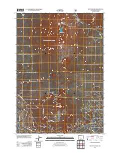
2011 Map of Mount Bachelor
USGS Topo · Published 2011About this map
Mount Bachelor Ski Area dominates this high-altitude landscape in the Deschutes National Forest, documented here through modern topographic detail. The map centers on the iconic volcanic profile of Mount Bachelor, tracing the established infrastructure of the recreational area including Sunrise Lodge and Pine Marten Lodge. To the north, the clear waters of Sparks Lake provide a sharp contrast to the surrounding volcanic peaks, while Dutchman Creek drains the northern slopes. The southern half of the sheet reveals an extensive network of forestry roads, such as Nat For Dev RD 300 and Siah Butte Rd, which navigate the high terrain surrounding Sheridan Mountain, Kwolh Butte, and Tot Mountain. This survey illustrates the intricate balance between recreational development and the preservation of the Cascade Range's natural features.
Find a feature on this map
15 named features on this map. Tap any name to fly to it.
Don’t see what you’re looking for? This feature index may not catch every label — zoom into the map to look around manually.
Map Details
Editions of this 2011 Mount Bachelor Map
This is the sole edition of this map. No revisions or reprints were ever made.
Other maps of this area

1929 · Three Sisters
USGS Topo · 1:125,000

1930 · Maiden Peak
USGS Topo · 1:125,000

1932 · Three Sisters
USGS Topo · 1:125,000

1934 · Maiden Peak
USGS Topo · 1:125,000

1955 · Crescent
USGS Topo · 1:250,000

1955 · Bend
USGS Topo · 1:250,000

1957 · Crescent
USGS Topo · 1:250,000

1957 · Bend
USGS Topo · 1:250,000

1958 · Crescent
USGS Topo · 1:250,000

1958 · Bend
USGS Topo · 1:250,000