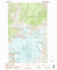
1989 Map of Mount Baker
USGS Topo · Published 1989About this map
The glaciated volcanic terrain of the Mt Baker National Forest dominates this topographic record, centered on the high peaks and permanent ice fields of the Mt Baker Wilderness. This 1980s-era data reflects the complex drainage and ice-flow patterns of the volcano, including the prominent Coleman Glacier on the western flank and the Deming Glacier to the south. Distinctive landmarks such as Grant Peak, the Roman Wall, and the Summit Crater define the high-altitude topography. Further down the slopes, the map identifies specific ridges and divides that channel meltwater into the regional system, such as Heliotrope Ridge and the Skyline Divide. The documentation of features like the Crater Moraine and Boulder Crags provides a valuable study of the physical geography before more recent glacial recession changed these alpine landscapes.
Find a feature on this map
50 named features on this map. Tap any name to fly to it.
Don’t see what you’re looking for? This feature index may not catch every label — zoom into the map to look around manually.
Map Details
Editions of this 1989 Mount Baker Map
2 editions found
Other maps of this area

1909 · Mt Baker
USGS Topo · 1:192,000

1915 · Mt. Baker
USGS Topo · 1:250,000

1952 · Lake Shannon
USGS Topo · 1:62,500

1952 · Mt. Baker
USGS Topo · 1:62,500

1952 · Hamilton
USGS Topo · 1:62,500

1953 · Mt Shuksan
USGS Topo · 1:62,500

1955 · Concrete
USGS Topo · 1:250,000

1958 · Concrete
USGS Topo · 1:250,000

1962 · Concrete
USGS Topo · 1:250,000
1973 · Hamilton
USGS Topo · 1:62,500