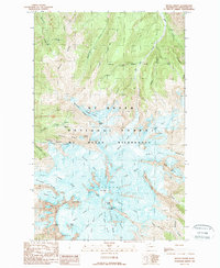
1989 Map of Mount Baker
USGS Topo · Published 1989About this map
Grant Peak and the high volcanic terrain of the Mt Baker Wilderness dominate this detailed 1989 topographic survey. The map provides an intricate look at the glacial systems radiating from the summit, including the expansive Coleman Glacier, Deming Glacier, and the Park Glacier. These frozen features are framed by prominent rock landmarks such as the Roman Wall, Cockscomb, and the Black Buttes, illustrating the complex geological anatomy of the peak during the late 20th century.
Find a feature on this map
52 named features on this map. Tap any name to fly to it.
Don’t see what you’re looking for? This feature index may not catch every label — zoom into the map to look around manually.
Map Details
Editions of this 1989 Mount Baker Map
2 editions found
Other maps of this area

1909 · Mt Baker
USGS Topo · 1:192,000

1915 · Mt. Baker
USGS Topo · 1:250,000

1952 · Lake Shannon
USGS Topo · 1:62,500

1952 · Mt. Baker
USGS Topo · 1:62,500

1952 · Hamilton
USGS Topo · 1:62,500

1953 · Mt Shuksan
USGS Topo · 1:62,500

1955 · Concrete
USGS Topo · 1:250,000

1958 · Concrete
USGS Topo · 1:250,000

1962 · Concrete
USGS Topo · 1:250,000
1973 · Hamilton
USGS Topo · 1:62,500