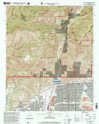
1995 Map of Mount Baldy
USGS Topo · Published 1999About this map
Mount Baldy serves as a northern anchor where the Angeles National Forest meets the San Bernardino National Forest. This 1995 revision reveals a landscape defined by the sharp transition from the steep drainages of San Antonio Creek and Cattle Canyon to the residential expansion of Claremont and Upland below. The infrastructure of the foothill communities is clearly visible, showing the San Antonio Dam and the Desilting Basin designed to manage the heavy runoff from the mountains. Cultural markers include the Padua Hills Theater and several educational institutions like Webb Sch and Pioneer Jr High School. The map also details the extensive wilderness areas, such as the Sheep Mountain Wilderness, which dominate the northern half of the quadrangle with names like Potato Mountain and Sunset Peak.
Find a feature on this map
62 named features on this map. Tap any name to fly to it.
Don’t see what you’re looking for? This feature index may not catch every label — zoom into the map to look around manually.
Map Details
Editions of this 1995 Mount Baldy Map
This is the sole edition of this map. No revisions or reprints were ever made.
Other maps of this area

1894 · Pomona
USGS Topo · 1:62,500

1897 · Pomona
USGS Topo · 1:62,500

1897 · Cucamonga
USGS Topo · 1:62,500

1898 · Pomona
USGS Topo · 1:62,500

1900 · Cucamonga
USGS Topo · 1:62,500

1901 · Southern California Sheet No. 1
USGS Topo · 1:250,000

1903 · Rock Creek
USGS Topo · 1:62,500

1903 · Cucamonga
USGS Topo · 1:62,500

1903 · San Antonio
USGS Topo · 1:62,500

1904 · Pomona
USGS Topo · 1:62,500