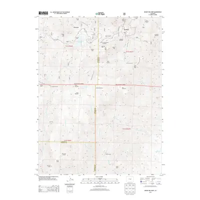
2013 Map of Mount Big Chief
USGS Topo · Published 2013About this map
Mount Big Chief and the high-elevation terrain of Pike National Forest dominate this landscape west of Colorado Springs, where the borders of Teller, El Paso, and Fremont counties converge. This 2013 survey documents a network of mountain settlements and recreational sites, including Rosemont and Duffield, alongside facilities like the Emerald Valley Boys Camp and Broadmoor Lodge. The cartography emphasizes water management and historic travel routes through the Front Range, specifically the Gold Camp Rd and the Penrose-Rosemont Reservoir. The rugged topography is further defined by landmarks such as Cheyenne Mountain, Saint Peters Dome, and the Devils Slide. The map also captures the intricate drainage patterns of the region, tracing the headwaters of Little Turkey Cr and Little Fountain Cr as they descend from the granite peaks and high meadows like Duffield Meadows.
Find a feature on this map
60 named features on this map. Tap any name to fly to it.
Don’t see what you’re looking for? This feature index may not catch every label — zoom into the map to look around manually.
Map Details
Editions of this 2013 Mount Big Chief Map
This is the sole edition of this map. No revisions or reprints were ever made.
Other maps of this area

1893 · Colorado Springs
USGS Topo · 1:125,000

1894 · Pikes Peak
USGS Topo · 1:125,000

1901 · Pikes Peak
USGS Topo · 1:125,000

1901 · Pikes Peak
USGS Topo · 1:62,500

1909 · Colorado Springs
USGS Topo · 1:125,000

1942 · Colorado Springs
USGS Topo · 1:125,000

1948 · Mount Big Chief
USGS Topo · 1:24,000

1948 · Mount Pittsburg
USGS Topo · 1:24,000

1948 · Timber Mountain
USGS Topo · 1:24,000

1948 · Manitou Springs
USGS Topo · 1:24,000